The WingtraOne mapping drone is a game-changing tool designed to revolutionize the way you collect surveying data. With its powerful features and cutting-edge technology, it enables users to maximize flying time and boost productivity both in the field and during data analysis at the office.
One of the standout features of the WingtraOne is its highly efficient fixed-wing flight capability. It can soar through the skies at an impressive speed of 36 mph for up to 59 minutes per flight, allowing you to cover vast areas in a single mission. What sets the WingtraOne apart from other drones is its remarkable 61 MP camera, capturing more ground and intricate details with each picture. This translates to larger areas covered per flight and unparalleled image quality. 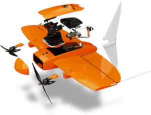
Gone are the days of painstakingly setting up ground control points (GCPs). The WingtraOne integrates an onboard high-precision PPK GNSS receiver, eliminating the need for extensive GCP placement. With as few as three checkpoints, you can verify the map’s quality, significantly reducing time and effort spent on mapping projects. Moreover, the drone’s top-notch optics ensure reliable map reconstruction even with lower image overlaps, maximizing coverage per flight line and enabling exploration of new areas.
In terms of speed, the WingtraOne surpasses multicopter drones by up to 11 times and standard fixed-wing drones by up to 2 times. This advantage allows the drone to tackle large-scale projects like mapping highways, industrial complexes, or mines within a few hours. By facilitating faster data collection and expanding coverage, the WingtraOne minimizes the need for personnel in the field, resulting in substantial cost savings.
The WingtraOne’s VTOL (Vertical Take-Off and Landing) design grants it the ability to operate in confined spaces or rough terrains that are inaccessible to other drones. This versatility broadens the range of data collection possibilities and enhances the drone’s utility in various environments. Additionally, the drone’s camera remains safely aloft throughout the flight, mitigating potential damage from ground contact and ensuring a longer equipment lifespan. 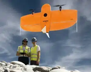
Safety and reliability are paramount for the WingtraOne. The drone has undergone rigorous testing, surpassing 300 trials, to ensure the highest quality standards. With over 100,000 successful flights and six years of continuous testing and enhancements, the WingtraOne boasts a proven track record of reliability and maximum uptime. Leveraging advanced machine learning algorithms, the drone employs predictive self-diagnosis, detecting and addressing component malfunctions based on thousands of flights. Additionally, it conducts automated safety checks on its sensors and actuators before every flight, guaranteeing safe and reliable operation.
Lastly, the WingtraOne has been added to the DIU (Defense Innovation Unit) Blue List. This means that the drone and the embedded technology has been tested and proven secure and compliant for purchase by DoD (Department of Defense) agencies, and contractors who are working on federal projects where this is required by the sponsoring agency.
The WingtraOne mapping drone offers a powerful combination of features that elevate efficiency, accuracy, and safety in aerial mapping projects. With its efficient flight capabilities, high-resolution camera, reduced reliance on GCPs, and unwavering performance, the WingtraOne empowers users to swiftly cover large areas, collect precise data, and optimize their operations. Experience the future of aerial surveys with the WingtraOne.

- Applications
-
- Telematics & Software
- Training, Support & Services
-
-
-
Training, Support & Services
-
-
-
- Blog
- Sales Contact
Accelerate Your Success
See how our solutions and technology can fast-track your productivity and profits.